| The Annual International Berkeley Undergraduate Prize for Architectural Design Excellence | |
|
|
|
[ID:1504] Shelter.India Pune; City of Virtue, an apt name for a city which has lived up to the expectations of people of many countries, who live in peace and progressive harmony above all creeds, all politics and all nationalities. A city that aspires to be a universal one, a city that epitomizes ‘New India’, with its baffling mix of capitalism, spiritualism, ancient and modern.
Pune was initially given pride of place by Chattrapati Shivaji Maharaj and the ruling Peshwas, who made it their capital. The center of power of the Maratha Empire has a glorious history of long, hard fought battles between the Marathas, the Moghuls, and the British.
The most outstanding aspect of this beautiful city and its people is the sound balance that they have maintained between modernity and their age-old rich culture and tradition. Most of the market streets, residential districts, all date back to 1600s.
Pune is considered the cultural capital of Maharashtra. Since the 1950s and 1960s, Pune has had traditional old-economy industries which continue to grow today. Add to these industries, government and private sector research institutes that attract migrants, students, and professionals from India, and abroad. Pune is a thriving center of academia and business, one of the fastest growing cities in Asia-Pacific.
No number of words is quite enough to aptly describe Pune. Hence, it is a shame to see such a beautiful city with such rich and wonderful history dying a slow, painful death.
In Pune, 45% of the population is living in slums that make up less than 10 percent of the city's area. It is saddening to find out that such a large number of our people live in such degraded environment. Despite their large numbers, slum dwellers are often ignored by urban planners and administrators due to lack of recognition of slum dwellers as legitimate residents of cities. As a result, slums often lack even the most basic civic infrastructure, including housing, drainage, water delivery, sewage systems and electricity. This lack of amenities creates serious health and security hazards for the inhabitants.
Slum inhabitants are considered transient and illegal, making financial investments less viable and discouraging political interest in slum improvement. Stereotypes of slum dwellers include: they are undeserving people who steal city land; live off taxpayers; are unemployed; and foster vices such as drugs, prostitution, and violence—providing officials with reasons for not investing government money on basic services. Lack of knowledge about slum conditions and demographics leads to inequitable and inefficient urban planning.
In a similar context, we have the city of Sangli. Irrespective of whether you live in a rural area or a bustling city, you can most likely find your home on a map. But what if your location lacks basic amenities like water, toilets, sanitation and even streets? This is the harsh reality of 15% of the population of this Indian city.
But there is a silver lining here. Enter Shelter Associates, who work with the urban poor to facilitate slum rehabilitation, resettlement initiatives and infrastructure projects. It is a Civil Society which was registered as a society and trust in 1994. The NGO (Non- Government Organization) is based in Pune, and comprises of architects, social workers and community workers whose focus is to enhance the quality of life of the urban poor living in slums.
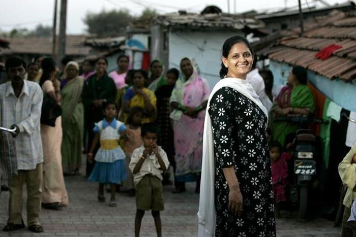
Ar.Pratima Joshi is one of the founding members of Shelter Associates and has been working here since its inception in 1993. Their plan is to prioritize the preparation and implementation of exemplary pilots, and use research findings to raise awareness about issues.
Shelter Associates (SA) work with slum communities and urban local bodies under the banner of Baandhani in the slums using a variety of approaches: new housing (with security of tenure); connection to essential service (including sanitation); health & education initiatives; and, livelihood projects.
SA is working for the recognition of slum dwellers as legitimate city residents with rights to basic public services. As an architect, Ar.Pratima Joshi is using her expertise to encourage urban planners and officials to address the lack of attention paid to slums in city development plans. By mobilizing slum youth to collect data and using GIS technology, SA is systematically generating and analyzing essential information on slum demographics. With GIS, SA has created a spatially-organized slum database that is critical to effective urban planning and the development of public infrastructure servicing the slums. SA is using this information to advocate for the poor and put pressure on public officials to for instance, resettle slum communities living within flood-prone areas to safer locations. SA is also facilitating the effective use of the data by local governments to negotiate budgets from the national government, coordinate city development plans, and design utilities that are truly beneficial to slum inhabitants. Importantly, SA is using concrete data to dissipate negative stereotypes of slum dwellers and create awareness about them as vibrant members of the community.
As Ar. Pratima Joshi says “SA believes in doing projects and then using them as tools for advocacy”.
SA has created a comprehensive data-collection project; a database of information on slum communities. It synthesizes information for each slum from a socio-economic household census, settlement level surveys, and settlement mapping. Using GIS software, this detailed information can be used by local and state governments— replacing assumptions with precise figures and plans—to help them lobby the national government for corresponding fund allocations.
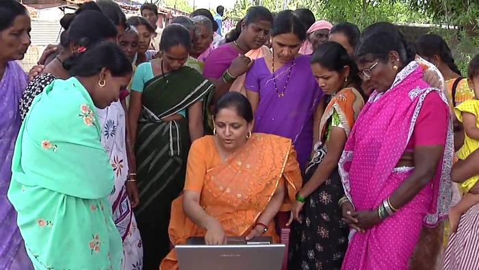
They have developed a uniquely successful ground-level survey methodology. Integral to its success is the involvement of slum-dwellers who collect data on their own communities. SA works with Baandhani, to train other slum residents to conduct house-to-house surveys. Teams collect data in slums throughout the city of Pune. All surveyors are young, around 18 to 20 years old, and are especially enthusiastic when they can see on the computer all their data being connected to houses in the settlements; able to identify their homes on the map and click the mouse for information. A visual representation makes the data special and personal in a way that other surveys have not.
SA understands the essential nature of spatial information to surveys, as slum settlements are spatial entities with layouts, topography and specific locations. Slums are living parts of the city with homes, roads, shops, temples, water channels, etc. Each slum is connected by networks of city infrastructure to its surrounding area and to the city as a whole. GIS is a tool which joins spatial analysis with socioeconomic information, and is therefore ideal for urban planning. At the micro-level, infrastructure projects, can best be planned using a combination of spatial and socio-economic information. A snapshot of a GIS map of Pune shows that slum settlements, are spread across the entire city. With this spatial data, SA has been able to argue effectively to city planners that it is more efficient to include slums in infrastructure networks than not. For example, where a sewage or water line is intended to supply a “regular” neighborhood it can also supply slum settlements located along the same route. SA has shown that integrating slum development into Pune’s city development is the most reasonable investment for efficient municipal spending. SA’s census validates the existence of slum dwellers in the city by providing concrete information about their residence in and contribution to the city. Seeing a house on the virtual map of a slum, one may access information about the family, legitimatizing city residents in a way that is difficult for public officials to challenge. This information also proves that slum dwellers are important contributors to Pune’s vibrant economy—an important part of SA’s vision for change: the spread of a broader awareness of slum residents as visible, viable communities within the city.
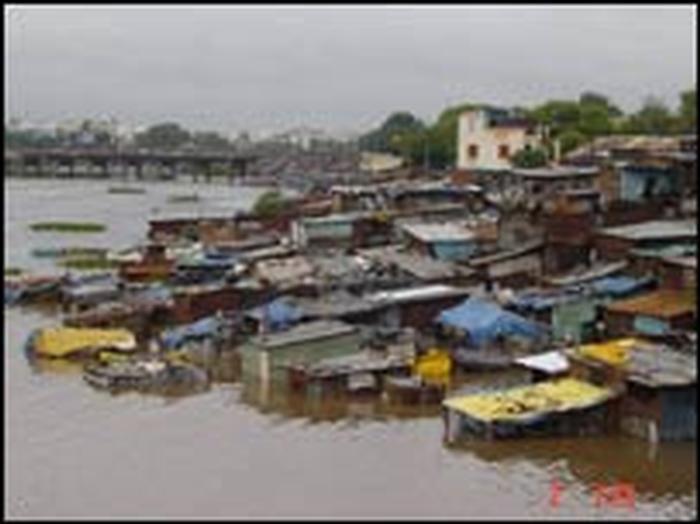
SA has also shown that if information about slum settlements is transparent and widely disseminated, public officials can be held accountable for their decisions about the allocation of resources. For example, a slum in Pune, Kamgar Putla, was severely damaged by one of the worst floods in 40 years. SA conducted a survey of affected houses, enabling the Pune municipality to draw a high flood line across the settlement and a resettlement plan.
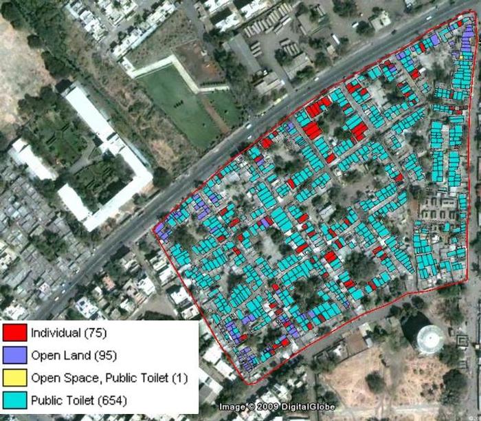
Spatial Slum Information Data collected in relation to the slums is arranged by city; organized spatially; and uploaded onto the SA website. Each set of information contains statistical data about the slums in that urban area including: land ownership; Development Plan reservations, survey number, population, condition of houses; condition of infrastructure; connection to services; etc. The information is a free online resource for all, including Municipal Corporations, and is maintained and updated by SA staff.
Google Earth has been used as a ‘base map’ to co-ordinate all of the GIS data, giving a citywide perspective. Google Earth was selected as it is the most commonly used, and most accessible, remote sensing technology that is available without any cost. Also because the development plan maps of the city were very often inaccurate. Google understood that Shelter Associates were using its Google Earth software in an innovative fashion and, in 2009, awarded Shelter Associates the title of ‘Google Earth Hero’.
Through google earth map, the entire city of Pune which has been divided into fifteen administrative wards has been digitized. By clicking on any of the wards, one can see that it is further subdivided into electoral wards. And all the slum boundaries are clearly visible in red. On clicking on the slum boundaries it gives the links to fact sheets of the respective slums. The fact sheets include the captured images of the recent infrastructure details of the slum, and the socio-economic data that has been aggregated and put out for that particular slum dwelling.
What exactly happens is that once you look at it on google earth, it is very easy to immediately place the slum in a context, with regards to the surroundings of the settlement. Thus you don’t look at the slum from an isolated and out of context approach, but instead one starts looking at all of it within the context of its neighborhood. Hence a “City-wide approach” is implemented for development planning.
When the city is considered as a whole, it is possible to compose holistic rehabilitation strategies that are sensitive to the situation of all slum dwellers in an area. When rehabilitation is carried out on a slum-by-slum basis, land is not utilized to its full potential and the opportunity to develop available sites optimally is lost. This means that slum dwellers residing on land with Development Plan reservations, or on land that is prone to flooding or non-buildable zones, cannot be in-situ rehabilitated and eventually get evicted and moved to the edge of the city which is damaging their way of life and driving them deeper into poverty.
To rehabilitate a slum while keeping it close to the place where the slum dwellers once stayed, it is very essential to have all the socio-economic information laid out in front at the city level of the degraded areas and of each and every member of the community before starting to take any sort of decision. Especially decisions pertaining to very important and scarce resources like land. So rehabilitation strategies are to be planned with utmost care, in order to ensure optimal usage of resources like land, water. Secondly, ensure that the community people are not uprooted from their livelihood, occupation and amenities and thrown out of their locality to the outskirts of the city where there is land available; because that can many a times drive people much deeper into poverty due to the longer travelling distances to their routine work and business places.
The goal of all of Shelter Associates projects is not to implement a project but to realize tangible positive change in the quality of the lives of urban poor.
Awareness generation comes in handy during execution of these plans, it is something that starts at a very basic level, with simple things like mapping & enumeration. Very often the people in slums are unaware of the existing situations including rudimentary information like the number of hutments in the settlement. On asking this simple question of the number, one can find that there is a whole variety and range of answers. SA informs slum dwellers about their immediate necessities.
SA also makes sure that the awareness drives that are conducted are very strong in nature, in order to convince the slum dwellers to relocate to new locality. Hence SA uses technology to a great extent to show the slum dwellers where exactly they are living and where they are proposed to be relocated; and subsequently convince them that it is not that far, but facilities like schools, bus-stands, hospitals, gathering areas, parks are all either the same or better than their current location. It is at this stage that the Baandhani community workers come to play, they talk to the slum people on a one-on-one or group basis to convince the people to relocate.
Despite all these cautiously planned initiatives taken by SA, there are many problems and hurdles that they face in each and every one of their ambitious projects.
“To bring the political or government’s interests into these projects is the toughest part of the entire process. There is a lot of apathy in dealing with the issues that concern the development for the underprivileged. The biggest hurdle is apathy, incompetent staff and sometimes corruption.” says Ar. Pratima Joshi.
A lot of things are not even mandated in the system. For example, it is important that all government projects are monitored regularly, and audits are conducted. This does not happen; hence the delayed project duration, cost escalation and poor construction, thus incomplete work. Ultimately the entire thing spirals out of control.
“We have got a whole methodology that has been worked out, a very sound one at that which we believe can be taken across the country in the urban areas, and this is where we would like to make an impact on urban sanitation in the years to come.”says the lady behind all of it.
SA provides plans for better amenities in slums: working with government to build a community-managed solid waste system in one of the slums as a model. SA is now working with the national Ministry of Urban Planning, partnering with state administrators to work with local governments in 10 cities in Maharashtra, and integrating their development planning processes with information generated on their slums.
With the building of new accommodation and drastic improvement in the conditions of the slums, the situation of the people who live in such places becomes better and their status in society improves. These people are no longer called slum dwellers, and the difference is dramatic. As Ar.Pratima Joshi tells, many families tell her: "Our daughters can get better bridegrooms because we are no longer slum-dwellers."
Although she says that what they have done is just a drop in the ocean, little drops make the mighty ocean, don’t they?
If you would like to contact this author, please send a request to info@berkeleyprize.org. |